Cannon Beach was named after a couple cannons were found in the the late 1800's, presumed to be from the U.S. Navy Survey ship "Shark". Surprisingly, two more cannons were discovered just south of the town in February. They have been recovered by the state and are now undergoing a long process to stabilize and preserve them for future display.
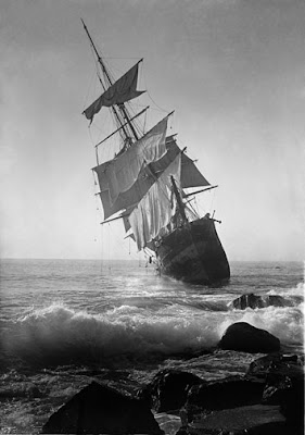
| The image above is from http://historicphotoarchive.com/caps/00068.html where you can also purchase copies The first time I saw this image I thought it must have been PhotoShopped. How would a ship in full sail have run on the rocks like that? What you can't see is that this is faced by a huge cliff and mountain that run right down to the sea, so not really even a surprise rocky shoal. It is real, the ship Glenesslin wrecked on Mt. Neahkahnie (also famous for legends of buried pirate treasure). Apparently more than a couple crew members had been into the spirits - another great reminder to "Boat sober". :?) |
For more information on the exposed shipwrecks, check out the Oregonian's coverage at http://blog.oregonlive.com/breakingnews/2008/02/oregon_shipwreck_identified_sh.html
I also ran across the following interactive map of the "Graveyard of the Pacific" - Columbia River bar. It shows you a time lapse of the shifting river topography and the wrecks from the mid 1800's to present. Interactive Columbia River Shipwreck Map the data was compiled by the staff of the Columbia River Maritime Museum which is worth a visit in person or on-line - http://www.crmm.org/. In addition to information on the spectacular museum, their site offers a live webcam of the Astoria, Oregon bayfront and the current weather station as well.
I don't know what made me think of it, but I thought I'd mention that at Savvyboater.com we offer a wide array of life jackets, inflatable life vests and personal flotation devices including life jackets for children and pet life vests.


1 comment:
Enjoyed reading your blog about this.
Enjoy the entire blog, really!
Come see our shipwreck chart...you might enjoy it (Dead Reckoning in the tag cloud).
http://nwlimited.wordpress.com
Post a Comment